

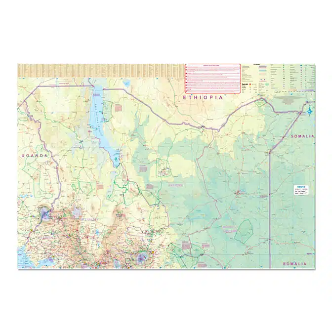
Kenya Travel Reference Map
Original price was: $15.95.$14.50Current price is: $14.50.
Our Kenya Travel Reference Map is the latest, updated edition from 2023. New highways, roads and sites are included. A must for anyone traveling to this incredibly birdy country.
Description
Scale: 1:950,000
ISBN: 9781771294164
Publisher: International Travel Maps
5th Edition Edition
Year of Publication: 2023
Our Kenya Travel Reference Map was published in 2023 and is the newest edition. Kenya is one of the most popular travel areas in Africa. A double-sided waterproof road map of Kenya. The best way to plan your trip, to prepare your itinerary, and to travel independently.
The legend is in English. Touristic information: roads by classification, highways, airports, ports, post offices, hospitals and medical facilities, campsites, rest houses, accommodations, border crossings, Unesco World Cultural Heritage sites, park gates, hot springs, beaches, rivers and lakes, national parks, points of interest, zoos, fishing, and much more…
- Map size: 27″ x 39″
- Major updated transportation routes
- Archaeological and Recreational sites
- National Parks, Wildlife Parks & Reserves
- International & Provincial borders
- All roads, highways, trails and road distances
- Elevation info
- Extensive labeling of physical features such as mountain ranges, valleys and peaks
- Tourist Information
- Points of Interest
- Detailed Scale of 1:950,000
Additional information
| Weight | .25 lbs |
|---|---|
| Dimensions | 3.94 × .25 × 9.76 in |
Related products
-
Sale!
Wildlife of Southern Africa
Original price was: $19.95.$18.00Current price is: $18.00. Add to cart -
Sale!

Wildlife of Madagascar
Original price was: $35.00.$31.50Current price is: $31.50. Read more -
Sale!

Panama Travel Reference Map
Original price was: $15.95.$14.50Current price is: $14.50. Read more -
Sale!
Costa Rica Travel Reference Map
Original price was: $15.95.$14.50Current price is: $14.50. Read more